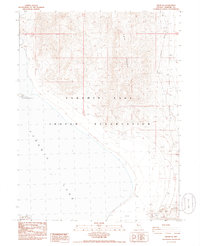
1985 Map of Nixon NW
USGS Topo · Published 1986About this map
Pyramid Lake Indian Reservation encompasses the rugged desert shoreline and mountainous terrain of this mid-1980s survey. The landscape is dominated by the vast waters of Pyramid Lake and the steep eastern slopes of the Lake Range, which rises sharply from the water's edge. This provisional mapping captures a remote section of the Nevada desert characterized by isolated natural landmarks and minimal human development, save for a few prospects and a Borrow Pit along the southeastern shoreline.
Find a feature on this map
9 named features on this map. Tap any name to fly to it.
Don’t see what you’re looking for? This feature index may not catch every label — zoom into the map to look around manually.
Map Details
Editions of this 1985 Nixon NW Map
This is the sole edition of this map. No revisions or reprints were ever made.
Other maps of this area

1886 · Granite Range
USGS Topo · 1:250,000

1890 · Wadsworth
USGS Topo · 1:125,000

1891 · Reno
USGS Topo · 1:125,000

1892 · Wadsworth
USGS Topo · 1:125,000

1893 · Reno
USGS Topo · 1:125,000

1894 · Granite Range
USGS Topo · 1:250,000

1894 · Wadsworth
USGS Topo · 1:125,000

1955 · Lovelock
USGS Topo · 1:250,000

1957 · Sutcliffe
USGS Topo · 1:62,500

1957 · Nixon
USGS Topo · 1:62,500