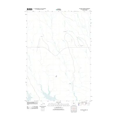
2012 Map of No Heart Creek
USGS Topo · Published 2012About this map
Lake Oahe defines the southern reach of this Dewey County landscape, where the Missouri River reservoir meets the mouth of Tall Prairie Chicken Cr. The terrain is characterized by a network of drainage systems feeding into the lake, including the winding course of No Heart Cr and the prominent No Heart Butte. This 2012 survey illustrates a sparse ranching economy in District 6, with family-named operations such as Fast Horse Ranch, Clark Ranch, Means Ranch, and Reeves Ranch distributed across the plains. Connectivity is limited to the central corridor of Bia Hwy 8, which traverses the undulating prairie between Corral Cr and the various branches of Willow Creek, such as Little Willow Cr and W Br Willow Cr. The map provides a detailed view of the Missouri River's backwaters and the isolated grazing lands of north-central South Dakota.
Find a feature on this map
12 named features on this map. Tap any name to fly to it.
Don’t see what you’re looking for? This feature index may not catch every label — zoom into the map to look around manually.
Map Details
Editions of this 2012 No Heart Creek Map
This is the sole edition of this map. No revisions or reprints were ever made.
Other maps of this area

1953 · McIntosh
USGS Topo · 1:250,000

1954 · Pierre
USGS Topo · 1:250,000

1958 · Pierre
USGS Topo · 1:250,000

1958 · McIntosh
USGS Topo · 1:250,000

1969 · Rousseau Creek
USGS Topo · 1:24,000

1969 · No Heart Creek SE
USGS Topo · 1:24,000

1969 · No Heart Creek SW
USGS Topo · 1:24,000

1981 · Charlie Creek
USGS Topo · 1:24,000
1981 · No Heart Creek NE
USGS Topo · 1:24,000
1981 · Stove Creek
USGS Topo · 1:24,000