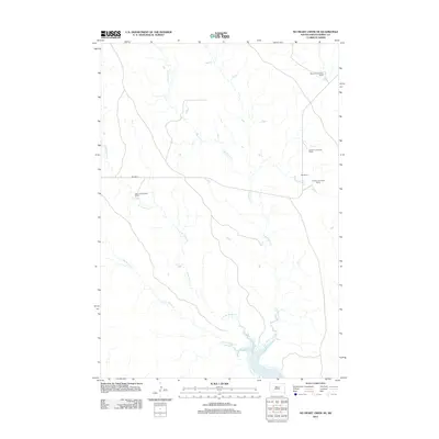
2012 Map of No Heart Creek NE
USGS Topo · Published 2012About this map
Lake Oahe serves as the focal point for this section of Dewey County, where the Missouri River reservoir defines the southern landscape. The terrain is characterized by a network of drainage systems, primarily Little Willow Cr and the eastern and western branches of Willow Creek, which carve through the plains toward the lake. This 2012 survey illustrates a sparsely populated ranching landscape, where activity is centered around established family holdings such as the Wayne Ducheneaux Ranch and Gordon LeCompte Ranch. Transport through this rural area relies on Bia Hwy 8, which provides the primary East-West transit across the northern portion of the sheet. The map offers a clear view of the land use patterns in South Dakota's river country, documenting the locations of specific ranching operations like the Opp Ranch and Henry Ducheneaux Ranch relative to the fluctuating shoreline of the reservoir.
Find a feature on this map
10 named features on this map. Tap any name to fly to it.
Don’t see what you’re looking for? This feature index may not catch every label — zoom into the map to look around manually.
Map Details
Editions of this 2012 No Heart Creek NE Map
This is the sole edition of this map. No revisions or reprints were ever made.
Other maps of this area

1953 · McIntosh
USGS Topo · 1:250,000

1954 · Pierre
USGS Topo · 1:250,000

1958 · Pierre
USGS Topo · 1:250,000

1958 · McIntosh
USGS Topo · 1:250,000

1965 · Artichoke Butte SW
USGS Topo · 1:24,000

1969 · No Heart Creek SE
USGS Topo · 1:24,000

1969 · Artichoke Butte NW
USGS Topo · 1:24,000

1969 · Patch Skin Buttes SW
USGS Topo · 1:24,000

1969 · No Heart Creek SW
USGS Topo · 1:24,000
1981 · No Heart Creek NE
USGS Topo · 1:24,000