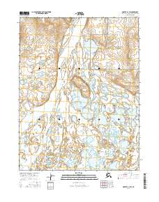
2016 Map of Noatak A-1 SW
USGS Topo · Published 2016About this map
Noatak National Preserve encompasses much of this riverine landscape, where the shifting hydrology of the Arctic wilderness is recorded in intricate detail. The massive Noatak River dominates the western portion of the sheet, carving a wide path through a mosaic of wetlands and braided channels. This 2016 survey illustrates the dynamic nature of northern watercourses, where features like Kinuk Island sit amidst a complex network of seasonal sloughs and ponds. Farther east, the Little Noatak Slough meanders through the flats, defining the drainage patterns that have shaped this region for generations. The lack of permanent structures or roads reflects the remote character of the Northwest Arctic, where the environment remains dictated by the cycles of the river and the protected status of the surrounding preserve.
Find a feature on this map
8 named features on this map. Tap any name to fly to it.
Don’t see what you’re looking for? This feature index may not catch every label — zoom into the map to look around manually.
Map Details
Editions of this 2016 Noatak A-1 SW Map
This is the sole edition of this map. No revisions or reprints were ever made.
Other maps of this area

1951 · Noatak
USGS Topo · 1:250,000

1951 · Kotzebue
USGS Topo · 1:250,000

1951 · Kotzebue D-1
USGS Topo · 1:63,360

1951 · Kotzebue D-2
USGS Topo · 1:63,360

1955 · Noatak
USGS Topo · 1:250,000
1955 · Noatak A-1
USGS Topo · 1:63,360
1955 · Noatak A-2
USGS Topo · 1:63,360

1958 · Kotzebue
USGS Topo · 1:250,000

1964 · Noatak
USGS Topo · 1:250,000

1964 · Kotzebue
USGS Topo · 1:250,000