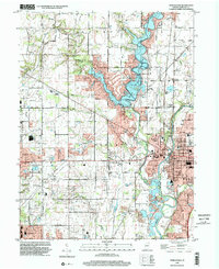
1998 Map of Noblesville
USGS Topo · Published 2002About this map
The Morse Reservoir dominates the center of this landscape, its winding branches formed by the flooded valleys of Hinkle Creek and Bear Slide Creek. This late 1990s data reflects a period of significant suburban expansion around Noblesville, where residential developments like Monterey Village sit adjacent to established landmarks such as the Courthouse and Riverview Hosp. To the east, the White River flows past the Potter Bridge and Riverside Cem, while the western portion of the sheet remains more rural, dotted with family-named roads like Anthony Road and Flippins Road. Genealogists will find several notable local landmarks, including Gray Friends Ch, the West Grove Cem, and several school sites ranging from the Indianapolis Boys Club Camp to the Conner Sch, illustrating the community's educational and religious infrastructure during the turn of the millennium.
Find a feature on this map
82 named features on this map. Tap any name to fly to it.
Don’t see what you’re looking for? This feature index may not catch every label — zoom into the map to look around manually.
Map Details
Editions of this 1998 Noblesville Map
This is the sole edition of this map. No revisions or reprints were ever made.
Other maps of this area

1952 · Fishers
USGS Topo · 1:24,000

1952 · Carmel
USGS Topo · 1:24,000

1952 · Mc Cordsville
USGS Topo · 1:24,000

1953 · Westfield
USGS Topo · 1:24,000

1953 · Riverwood
USGS Topo · 1:24,000

1953 · Noblesville
USGS Topo · 1:24,000

1953 · Cincinnati
USGS Topo · 1:250,000

1953 · Danville
USGS Topo · 1:250,000

1953 · Indianapolis
USGS Topo · 1:250,000

1953 · Muncie
USGS Topo · 1:250,000