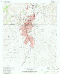
1981 Map of Nogales
USGS Topo · Published 1981About this map
Nogales sits as a critical international crossroads on this 1981 survey, straddling the border between Arizona and Sonora. The map documents the sprawling urban development that flows across the line, from the northern neighborhoods of Crawford Hill and Buenos Aires to the southern colonias including Colonia Pemex, Cinco de Mayo, and Pueblo Nuevo. This cross-border connectivity is centered around the U.S. Customs facility and the transit corridor of Interstate 19, which joins the historic reach of the Southern Pacific railroad.
Find a feature on this map
93 named features on this map. Tap any name to fly to it.
Don’t see what you’re looking for? This feature index may not catch every label — zoom into the map to look around manually.
Map Details
Editions of this 1981 Nogales Map
This is the sole edition of this map. No revisions or reprints were ever made.
Other maps of this area

1905 · Nogales
USGS Topo · 1:125,000

1921 · Old Glory
USGS Topo · 1:125,000

1933 · Calabasas
USGS Topo · 1:62,500

1942 · Ruby
USGS Topo · 1:62,500

1943 · Old Glory
USGS Topo · 1:125,000

1956 · Nogales
USGS Topo · 1:250,000
1957 · Ruby
USGS Topo · 1:62,500

1958 · Nogales
USGS Topo · 1:250,000
1958 · Nogales
USGS Topo · 1:62,500

1959 · Nogales
USGS Topo · 1:250,000