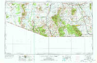
1956 Map of Nogales
USGS Topo · Published 1978About this map
The Santa Cruz River valley and surrounding mountains define this international border landscape in the mid-1950s. The map captures a transition from tribal lands in the west to the cattle and ranching country of the east, showing the Papago Indian Reservation and its numerous small settlements like Sells and Ali Chukson. Scientific and defense installations appear as modern anchors in the high desert, most notably the Kitt Peak National Observatory and the Sahuarita Bombing and Gunnery Range.
Find a feature on this map
121 named features on this map. Tap any name to fly to it.
Don’t see what you’re looking for? This feature index may not catch every label — zoom into the map to look around manually.
Map Details
Editions of this 1956 Nogales Map
4 editions found

Other maps of this area

1902 · Bisbee
USGS Topo · 1:62,500

1904 · Patagonia
USGS Topo · 1:125,000

1904 · Tucson
USGS Topo · 1:125,000

1905 · Patagonia
USGS Topo · 1:125,000

1905 · Tucson
USGS Topo · 1:125,000

1905 · Nogales
USGS Topo · 1:125,000

1910 · Bisbee
USGS Topo · 1:62,500

1914 · Hereford
USGS Topo · 1:125,000

1915 · Benson
USGS Topo · 1:125,000

1916 · Pearce
USGS Topo · 1:125,000