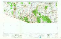
1956 Map of Nogales
USGS Topo · Published 1968About this map
The United States-Mexico borderlands are meticulously documented in this mid-century survey, revealing a landscape of remote ranching outposts and high-desert mining operations. The southern reach of the Santa Cruz River anchors the geography, flowing past the historic missions and settlements of Tubac and Nogales. To the east, the map details the legendary mining district of Tombstone and the significant military presence at Fort Huachuca Military Reservation.
Find a feature on this map
90 named features on this map. Tap any name to fly to it.
Don’t see what you’re looking for? This feature index may not catch every label — zoom into the map to look around manually.
Map Details
Editions of this 1956 Nogales Map
4 editions found

Other maps of this area

1902 · Bisbee
USGS Topo · 1:62,500

1904 · Patagonia
USGS Topo · 1:125,000

1904 · Tucson
USGS Topo · 1:125,000

1905 · Patagonia
USGS Topo · 1:125,000

1905 · Tucson
USGS Topo · 1:125,000

1905 · Nogales
USGS Topo · 1:125,000

1910 · Bisbee
USGS Topo · 1:62,500

1914 · Hereford
USGS Topo · 1:125,000

1915 · Benson
USGS Topo · 1:125,000

1916 · Pearce
USGS Topo · 1:125,000