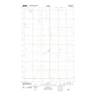
2011 Map of Nome
USGS Topo · Published 2011About this map
Nome stands as the central point of this agricultural landscape in southeastern North Dakota. The settlement is organized around a small grid of streets including Main St, 1st St N, and 1st St S, surrounded by a vast section-line road network. The geography is defined by numerous small water bodies and seasonal wetlands that dot the prairie, particularly along 125th Ave SE and 127th Ave SE. This layout illustrates the persistent 19th-century land survey grid as it functioned in the early 21st century, where local travel was dictated by a strictly cardinal system of township roads like 48th St SE and 51st St SE.
Find a feature on this map
20 named features on this map. Tap any name to fly to it.
Don’t see what you’re looking for? This feature index may not catch every label — zoom into the map to look around manually.
Map Details
Editions of this 2011 Nome Map
This is the sole edition of this map. No revisions or reprints were ever made.
Other maps of this area

1897 · Tower
USGS Topo · 1:125,000

1953 · Fargo
USGS Topo · 1:250,000

1956 · Fargo
USGS Topo · 1:250,000

1965 · Lucca
USGS Topo · 1:24,000

1965 · Tower City SW
USGS Topo · 1:24,000

1967 · Ft. Ransom
USGS Topo · 1:24,000

1967 · Fingal
USGS Topo · 1:24,000

1967 · Fingal SW
USGS Topo · 1:24,000
1967 · Nome SE
USGS Topo · 1:24,000
1967 · Nome
USGS Topo · 1:24,000