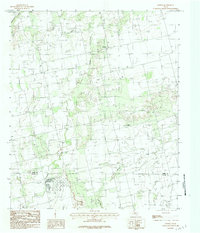
1984 Map of Noodle
USGS Topo · Published 1984About this map
The small settlement of Noodle serves as the focal point for this rural landscape along the boundary of Jones Co Taylor Co. This mid-1970s land-use pattern is defined by a network of drainage ways including Noodle Creek and Bitter Creek, which cut through the agricultural terrain. The map captures the industrial and infrastructural development of the era, from the energy-related Pumping Station and Oil Field to a local Landing Strip. A Gravel Pit near the town center and a Trailer Park further south reflect the local economy and housing patterns during this period of West Texas history. The topography is further shaped by hydraulic engineering, such as a Dike situated near Sweetwater Creek, indicating efforts to manage water flow in this semi-arid region.
Find a feature on this map
16 named features on this map. Tap any name to fly to it.
Don’t see what you’re looking for? This feature index may not catch every label — zoom into the map to look around manually.
Map Details
Editions of this 1984 Noodle Map
This is the sole edition of this map. No revisions or reprints were ever made.
Other maps of this area

1890 · Abilene
USGS Topo · 1:125,000

1891 · Anson
USGS Topo · 1:125,000

1892 · Abilene
USGS Topo · 1:125,000

1893 · Roby
USGS Topo · 1:125,000

1893 · Anson
USGS Topo · 1:125,000

1893 · Sweetwater
USGS Topo · 1:125,000

1954 · Big Spring
USGS Topo · 1:250,000

1954 · Abilene
USGS Topo · 1:250,000

1957 · Hawley
USGS Topo · 1:62,500

1957 · Merkel
USGS Topo · 1:62,500