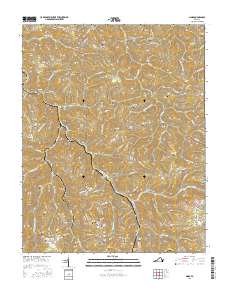
2016 Map of Nora
USGS Topo · Published 2016About this map
McClure River and its numerous tributaries, including Trammel Cr and Open Fork, carve through the complex ridge systems of Dickenson County. The settlement pattern follows these deep drainages, with the rail-dependent communities of Trammel, Wakenva, and Nora clustered along the valley floors. The landscape is defined by its industrial transit infrastructure, notably the Sandy Ridge Tunnel and Buffalo Tunnel, which pierce the high elevations of the Tennessee Valley Divide. Numerous family burial grounds, such as Salyer Cem, Rasnick Cem, and Dameron Cem, are perched on the steep slopes of Counts Ridge and Skeens Ridge. This topography reveals the persistent isolation of Appalachian hollows, where even 21st-century map data shows a dense network of private family cemeteries and small creek-side settlements like Aily and McClure.
Find a feature on this map
165 named features on this map. Tap any name to fly to it.
Don’t see what you’re looking for? This feature index may not catch every label — zoom into the map to look around manually.
Map Details
Editions of this 2016 Nora Map
This is the sole edition of this map. No revisions or reprints were ever made.
Other maps of this area

1886 · Grundy
USGS Topo · 1:125,000

1890 · Grundy
USGS Topo · 1:125,000

1892 · Grundy
USGS Topo · 1:125,000

1897 · Bristol
USGS Topo · 1:125,000

1902 · Bristol
USGS Topo · 1:125,000

1913 · Clintwood
USGS Topo · 1:62,500

1914 · Bucu
USGS Topo · 1:48,000

1915 · Clintwood
USGS Topo · 1:62,500

1916 · Bucu
USGS Topo · 1:62,500

1918 · Carterton
USGS Topo · 1:62,500