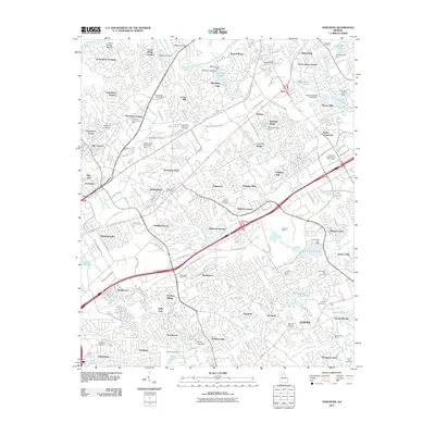
2011 Map of Norcross
USGS Topo · Published 2011About this map
The Chattahoochee River forms a natural northwest border for this suburbanizing corridor, where traditional landmarks like Scotts Mill and Hopkins Mill meet the rapid growth of the early 21st century. The landscape is defined by its transition from older river crossings like Jones Bridge Landing to sprawling corporate and residential hubs, including Technology Park Atlanta and Peachtree Corners. Genealogy and local history are preserved in numerous family burial grounds, such as the Goodwin Cemetery and Buchannen-King Cemetery, which remain tucked among modern developments like Sheffield Forest and Pleasant Acres. Extensive infrastructure is evident through the path of Peachtree Industrial Blvd and the Norcross Quarry, highlighting the area's role as a major industrial and logistics center. Water features also mark the terrain, from the recreation-focused Berkeley Lake to several smaller reservoirs including Freeman Lake and Cardinal Lake.
Find a feature on this map
125 named features on this map. Tap any name to fly to it.
Don’t see what you’re looking for? This feature index may not catch every label — zoom into the map to look around manually.
Map Details
Editions of this 2011 Norcross Map
This is the sole edition of this map. No revisions or reprints were ever made.
Other maps of this area

1888 · Atlanta
USGS Topo · 1:125,000

1890 · Suwanee
USGS Topo · 1:125,000

1890 · Atlanta
USGS Topo · 1:125,000

1892 · Atlanta
USGS Topo · 1:125,000

1894 · Suwanee
USGS Topo · 1:125,000

1895 · Atlanta
USGS Topo · 1:125,000

1953 · Atlanta
USGS Topo · 1:250,000

1954 · Chamblee
USGS Topo · 1:24,000

1954 · Decatur
USGS Topo · 1:24,000

1955 · Rome
USGS Topo · 1:250,000