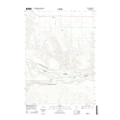
2014 Map of Norden
USGS Topo · Published 2014About this map
Niobrara River canyons define this section of the Nebraska Sandhills, cutting a deep path through the border of Keya Paha and Brown counties. The small settlement of Norden serves as the primary upland anchor, situated north of the river and connected to the valley floor via Norden Rd. This road provides critical access to the Norden Bridge, which spans the waterway near the Niobrara National Scenic River boundary.
Find a feature on this map
16 named features on this map. Tap any name to fly to it.
Don’t see what you’re looking for? This feature index may not catch every label — zoom into the map to look around manually.
Map Details
Editions of this 2014 Norden Map
This is the sole edition of this map. No revisions or reprints were ever made.
Other maps of this area

1950 · Norden
USGS Topo · 1:62,500

1950 · Huddle Table
USGS Topo · 1:24,000

1950 · Wood Lake
USGS Topo · 1:62,500

1952 · Norden
USGS Topo · 1:62,500

1954 · Ainsworth NW
USGS Topo · 1:24,000

1955 · O'Neill
USGS Topo · 1:250,000

1957 · Valentine
USGS Topo · 1:250,000

1959 · Valentine
USGS Topo · 1:250,000

1959 · O'Neill
USGS Topo · 1:250,000
1964 · Meadville NW
USGS Topo · 1:24,000