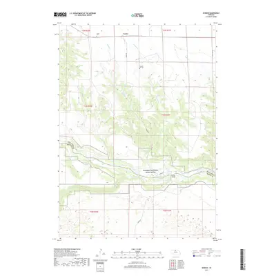
2017 Map of Norden
USGS Topo · Published 2017About this map
Norden anchors the northern high plains of Keya Paha County in this 2017 study, situated just above the complex drainage networks of the Niobrara River. The landscape is defined by the deep incision of the Niobrara National Scenic River valley, where the water has carved through the plateau to create distinctive features like Kuhns Rapid and the Norden Chute. This map is particularly valuable for genealogical research, documenting the locations of the Norden Cem and Pleasant Vale Cem, alongside the critical crossing at Norden Bridge. Numerous seasonal and perennial waterways, including Middle Cr, E Middle Cr, and Fairfield Cr, trace the rugged descent from the flat tablelands toward the river valley. The transition from the open prairie of the north to the wooded breaks along the county line between Keya Paha and Brown Counties highlights the diverse topography of north-central Nebraska.
Find a feature on this map
23 named features on this map. Tap any name to fly to it.
Don’t see what you’re looking for? This feature index may not catch every label — zoom into the map to look around manually.
Map Details
Editions of this 2017 Norden Map
This is the sole edition of this map. No revisions or reprints were ever made.
Other maps of this area

1950 · Norden
USGS Topo · 1:62,500

1950 · Huddle Table
USGS Topo · 1:24,000

1950 · Wood Lake
USGS Topo · 1:62,500

1952 · Norden
USGS Topo · 1:62,500

1954 · Ainsworth NW
USGS Topo · 1:24,000

1955 · O'Neill
USGS Topo · 1:250,000

1957 · Valentine
USGS Topo · 1:250,000

1959 · Valentine
USGS Topo · 1:250,000

1959 · O'Neill
USGS Topo · 1:250,000
1964 · Meadville NW
USGS Topo · 1:24,000