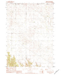
1983 Map of Norden NW
USGS Topo · Published 1984About this map
The Rosebud Indian Reservation spans the northern border of this Nebraska-South Dakota boundary region, where cattle ranching defines the social and economic landscape of the early 1980s. The terrain is marked by a network of family-named operations including the Lawrence Ranch, Fullerton Ranch, and Breuklander Ranch, illustrating a pattern of large-scale land use in Keya Paha Co and Cherry Co. Water sources like Beaver Creek and Shadley Creek provide the necessary irrigation for this high-plains environment.
Find a feature on this map
19 named features on this map. Tap any name to fly to it.
Don’t see what you’re looking for? This feature index may not catch every label — zoom into the map to look around manually.
Map Details
Editions of this 1983 Norden NW Map
This is the sole edition of this map. No revisions or reprints were ever made.
Other maps of this area

1950 · Norden
USGS Topo · 1:62,500

1950 · Sparks
USGS Topo · 1:62,500

1952 · Norden
USGS Topo · 1:62,500

1955 · Martin
USGS Topo · 1:250,000

1957 · Valentine
USGS Topo · 1:250,000

1958 · Martin
USGS Topo · 1:250,000

1959 · Valentine
USGS Topo · 1:250,000

1982 · Keyapaha SE
USGS Topo · 1:24,000

1982 · Hidden Timber SE
USGS Topo · 1:24,000
1982 · Keyapaha
USGS Topo · 1:24,000