
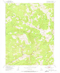
2000 Map of Norden
USGS Topo · Published 2003About this map
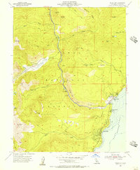
Norden and the high Sierra Nevada passes define this landscape at the turn of the millennium, where historic transportation corridors and modern recreation converge. The Southern Pacific Railroad winds through the terrain alongside numerous snowsheds, tracing the same critical route through Summit Valley once followed by early pioneers. Evidence of this migration is preserved via the Overland Emigrant Trail and the Emigrant Trail, which cross the granite ridges near Donner Pass.
Find a feature on this map
67 named features on this map. Tap any name to fly to it.
Don’t see what you’re looking for? This feature index may not catch every label — zoom into the map to look around manually.
Map Details
Editions of this 2000 Norden Map
This is the sole edition of this map. No revisions or reprints were ever made.
Other maps of this area

1891 · Truckee
USGS Topo · 1:125,000

1893 · Truckee
USGS Topo · 1:125,000

1895 · Truckee
USGS Topo · 1:125,000

1932 · Truckee
USGS Topo · 1:96,000

1940 · Truckee
USGS Topo · 1:125,000
1953 · Granite Chief
USGS Topo · 1:24,000
1953 · Royal Gorge
USGS Topo · 1:24,000
1953 · Granite Chief
USGS Topo · 1:62,500
1955 · Truckee
USGS Topo · 1:24,000
1955 · Tahoe City
USGS Topo · 1:24,000