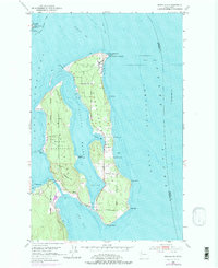
1953 Map of Nordland
USGS Topo · Published 1975About this map
Marrowstone Island and the neighboring shoreline of the Quimper Peninsula define this coastal landscape as it appeared in the mid-20th century. The settlement of Nordland sits centrally on the island's eastern coast, overlooking the waters of Mystery Bay. This period reflects a significant military and maritime presence, with the Coast Guard Reservation at Marrowstone Point and a large Naval Reservation on the western shore.
Find a feature on this map
33 named features on this map. Tap any name to fly to it.
Don’t see what you’re looking for? This feature index may not catch every label — zoom into the map to look around manually.
Map Details
Editions of this 1953 Nordland Map
4 editions found
Other maps of this area

1937 · Port Gamble
USGS Topo · 1:62,500

1939 · Port Townsend
USGS Topo · 1:62,500

1939 · Coupeville
USGS Topo · 1:62,500

1940 · Port Gamble
USGS Topo · 1:62,500

1940 · Quilcene
USGS Topo · 1:62,500

1953 · Hansville
USGS Topo · 1:24,000

1953 · Coupeville
USGS Topo · 1:24,000

1953 · Freeland
USGS Topo · 1:24,000

1953 · Nordland
USGS Topo · 1:24,000

1953 · Center
USGS Topo · 1:24,000