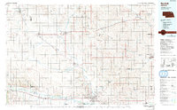
1985 Map of Norfolk
USGS Topo · Published 1991About this map
Norfolk serves as the regional anchor for this mid-1980s landscape, positioned at the convergence of the North Fork Elkhorn River and the Elkhorn River. The map captures a period of institutional growth, marking the Northeast Technical Community College and the Norfolk Regional Center as prominent local landmarks. Further east, the town of Wayne is dominated by the campus of Wayne State College, reflecting the area's role as an educational hub for northeast Nebraska. The land is defined by a dense network of creeks, including the channeled Logan Creek Dredge, which illustrates the modification of the prairie for agricultural stability. Smaller settlements such as Pierce, Randolph, and Plainview are evenly distributed along the road and rail corridors, maintaining the traditional prairie town grid. Significant landmarks like the Lutheran Community Hospital underscore the development of civic services during this era, while numerous smaller streams like Humbug Creek and Willow Creek trace the natural drainage of the rolling terrain.
Find a feature on this map
57 named features on this map. Tap any name to fly to it.
Don’t see what you’re looking for? This feature index may not catch every label — zoom into the map to look around manually.
Map Details
Editions of this 1985 Norfolk Map
2 editions found
Other maps of this area

1898 · Elk Point
USGS Topo · 1:125,000

1901 · Elk Point
USGS Topo · 1:125,000

1907 · Elk Point
USGS Topo · 1:125,000

1954 · Verdigre
USGS Topo · 1:24,000

1955 · Broken Bow
USGS Topo · 1:250,000

1955 · Sioux City
USGS Topo · 1:250,000

1955 · Fremont
USGS Topo · 1:250,000

1955 · O'Neill
USGS Topo · 1:250,000

1956 · Broken Bow
USGS Topo · 1:250,000

1957 · Fremont
USGS Topo · 1:250,000