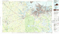
1985 Map of Norfolk
USGS Topo · Published 1986About this map
The Great Dismal Swamp National Wildlife Refuge dominates the center of this Tidewater survey, centering on Lake Drummond and extending south into North Carolina's Dismal Swamp State Park. This mid-1980s landscape illustrates a high-density urban corridor connecting Norfolk, Portsmouth, and Virginia Beach with the rural outposts and agricultural crossroads to the west. The maritime and military influence is evident through Oceana Naval Air Station, Fort Story Military Reservation, and the varied shipping channels of the Elizabeth River and Lynnhaven Roads.
Find a feature on this map
68 named features on this map. Tap any name to fly to it.
Don’t see what you’re looking for? This feature index may not catch every label — zoom into the map to look around manually.
Map Details
Editions of this 1985 Norfolk Map
3 editions found
Other maps of this area

1893 · Virginia Beach
USGS Topo · 1:125,000

1906 · Beckford
USGS Topo · 1:48,000

1907 · Norfolk
USGS Topo · 1:125,000

1907 · Beckford
USGS Topo · 1:62,500

1907 · Yorktown
USGS Topo · 1:62,500

1907 · Hampton
USGS Topo · 1:62,500

1908 · Winton
USGS Topo · 1:62,500

1916 · Back Bay
USGS Topo · 1:62,500

1918 · Cape Henry
USGS Topo · 1:62,500

1919 · Smithfield
USGS Topo · 1:62,500