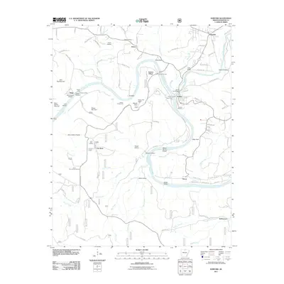
2011 Map of Norfork
USGS Topo · Published 2011About this map
The confluence of the White River and North Fork River anchors this study of north-central Arkansas, highlighting the settlement patterns at Norfork and nearby Salesville. The terrain is deeply defined by narrow hollows and high points, including Shipps Mountain and Matney Knob, which features the Matney Knob Lookout Tower. Significant genealogy and local-history value is found in the distribution of rural burial grounds such as the Burnt School House Cemetery, Arkana Cemetery, and Lone Rock Cemetery. The persistence of river crossings is evident through established points like Shipps Ferry and Martins Ferry, while the landscape is dotted with smaller communities like Arkana, Lone Rock, and Herron. These landmarks, along with many named drainages like Big Creek and Walker Creek, illustrate the historical development of Baxter County as it navigated the complex topography of the Ozark region.
Find a feature on this map
113 named features on this map. Tap any name to fly to it.
Don’t see what you’re looking for? This feature index may not catch every label — zoom into the map to look around manually.
Map Details
Editions of this 2011 Norfork Map
This is the sole edition of this map. No revisions or reprints were ever made.
Other maps of this area

1890 · Mountain Home
USGS Topo · 1:125,000

1891 · Mountain Home
USGS Topo · 1:125,000

1894 · Mountain Home
USGS Topo · 1:125,000

1945 · Harrison
USGS Topo · 1:250,000

1949 · Harrison
USGS Topo · 1:250,000

1954 · Harrison
USGS Topo · 1:250,000

1958 · Harrison
USGS Topo · 1:250,000

1964 · Harrison
USGS Topo · 1:250,000
1964 · Calico Rock
USGS Topo · 1:24,000
1964 · Norfork Dam South
USGS Topo · 1:24,000