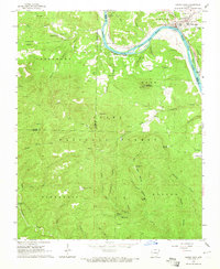
1964 Map of Calico Rock
USGS Topo · Published 1965About this map
The White River carves a dramatic path through this section of the Ozarks, serving as a natural boundary for Stone and Izard counties. In this mid-1960s landscape, the river remains a central artery for transportation and industry, evidenced by the Ghesmond Ferry and another local ferry crossing near the Gaging Sta. The town of Calico Rock sits at the river's bend, while smaller settlements like Culp and Optimus are tucked into the interior hills. The area is marked by a deep genealogical footprint, with numerous family-named burial grounds such as Rorie Cem and Casteel Cem scattered near rural landmarks like Table Rock Ch and Bethel Springs Sch. Higher elevations are punctuated by the Sugarloaf Lookout Tower and Green Lookout Tower, which overlook the timbered expanses of the Ozark National Forest.
Find a feature on this map
75 named features on this map. Tap any name to fly to it.
Don’t see what you’re looking for? This feature index may not catch every label — zoom into the map to look around manually.
Map Details
Editions of this 1964 Calico Rock Map
4 editions found
Other maps of this area

1890 · Mountain Home
USGS Topo · 1:125,000

1891 · Mountain Home
USGS Topo · 1:125,000

1892 · Mountain View
USGS Topo · 1:125,000

1894 · Mountain View
USGS Topo · 1:125,000

1894 · Mountain Home
USGS Topo · 1:125,000

1945 · Harrison
USGS Topo · 1:250,000

1949 · Harrison
USGS Topo · 1:250,000

1954 · Harrison
USGS Topo · 1:250,000

1956 · Russellville
USGS Topo · 1:250,000

1958 · Harrison
USGS Topo · 1:250,000