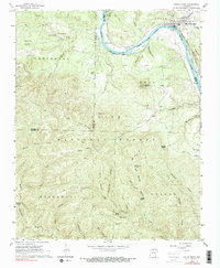
1964 Map of Calico Rock
USGS Topo · Published 1990About this map
White River carving through the heart of northern Arkansas dominates this mid-century topographic record, where the Missouri Pacific railroad snakes along the northern bank past City Rock Bluff. The landscape is a mix of small river-valley settlements like Calico Rock and upland community hubs such as Culp and Optimus. Evidence of early education and local kinship is found in landmarks like Bethel Springs Sch and numerous family burying grounds including Cope Cem and Rorie Cem. Crossing points like Chesmond Ferry highlight the historical reliance on water transport before the extensive development of modern bridges. The terrain is marked by significant elevations like Sugarloaf Mountain and Hixon Mountain, while the dense Ozark National Forest covers much of the southern portion of the quadrangle, punctuated by isolated features like Saltpeter Cave and the Green Lookout Tower.
Find a feature on this map
78 named features on this map. Tap any name to fly to it.
Don’t see what you’re looking for? This feature index may not catch every label — zoom into the map to look around manually.
Map Details
Editions of this 1964 Calico Rock Map
4 editions found
Other maps of this area

1890 · Mountain Home
USGS Topo · 1:125,000

1891 · Mountain Home
USGS Topo · 1:125,000

1892 · Mountain View
USGS Topo · 1:125,000

1894 · Mountain View
USGS Topo · 1:125,000

1894 · Mountain Home
USGS Topo · 1:125,000

1945 · Harrison
USGS Topo · 1:250,000

1949 · Harrison
USGS Topo · 1:250,000

1954 · Harrison
USGS Topo · 1:250,000

1956 · Russellville
USGS Topo · 1:250,000

1958 · Harrison
USGS Topo · 1:250,000