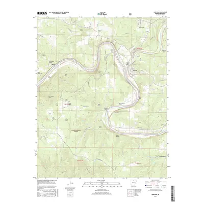
2017 Map of Norfork
USGS Topo · Published 2017About this map
The confluence of the White River and the North Fork River anchors this study of Baxter County, where the town of Norfork sits at the junction of these major waterways. The landscape is defined by the winding river valleys and the ridges of the Ozark National Forest, including Shipps Mtn and Matney Knob. Local heritage is preserved in numerous rural landmarks, such as the Burnt School House Cem and Norfork Cem, while the North Fork Bridge provides a critical crossing point for the region’s road network. The map reveals a pattern of dispersed settlements like Lone Rock, Arkana, and Salesville, often tucked between steep terrain such as Wild Hog Mtn and White Bluff. This 2017 edition documents the modern layout of rural homesteads and mountain hollows, from Ellen Cockran Hollow to Hopewell Hollow, illustrating how topography continues to dictate the development of this Arkansas river country.
Find a feature on this map
112 named features on this map. Tap any name to fly to it.
Don’t see what you’re looking for? This feature index may not catch every label — zoom into the map to look around manually.
Map Details
Editions of this 2017 Norfork Map
This is the sole edition of this map. No revisions or reprints were ever made.
Other maps of this area

1890 · Mountain Home
USGS Topo · 1:125,000

1891 · Mountain Home
USGS Topo · 1:125,000

1894 · Mountain Home
USGS Topo · 1:125,000

1945 · Harrison
USGS Topo · 1:250,000

1949 · Harrison
USGS Topo · 1:250,000

1954 · Harrison
USGS Topo · 1:250,000

1958 · Harrison
USGS Topo · 1:250,000

1964 · Harrison
USGS Topo · 1:250,000
1964 · Calico Rock
USGS Topo · 1:24,000
1964 · Norfork Dam South
USGS Topo · 1:24,000