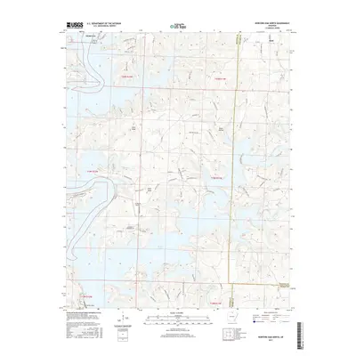
2017 Map of Norfork Dam North
USGS Topo · Published 2017About this map
Norfork Lake dominates this 2017 survey, its expansive reach defined by the towering Norfork Dam at the southern edge of the quadrangle. The irregular shoreline of the reservoir creates numerous peninsulas and coves where residential development, such as Henderson and Ruth, clings to the high ground above the water. The intricate network of local county roads, including Co Rd 91 and Co Rd 139, navigates the complex terrain of the Ozark foothills. Isolated peaks like Flint Knob and Wolf Knob rise above the drainage basins of Diamond Cr and Float Cr. This modern topographic study shows the contemporary interface between public infrastructure and the private lands surrounding the lake, including aviation access at The Bluffs Airport and the jurisdictional boundaries where Baxter Co meets Fulton Co and Izard Co.
Find a feature on this map
80 named features on this map. Tap any name to fly to it.
Don’t see what you’re looking for? This feature index may not catch every label — zoom into the map to look around manually.
Map Details
Editions of this 2017 Norfork Dam North Map
This is the sole edition of this map. No revisions or reprints were ever made.
Other maps of this area

1890 · Mountain Home
USGS Topo · 1:125,000

1891 · Mountain Home
USGS Topo · 1:125,000

1894 · Mountain Home
USGS Topo · 1:125,000

1945 · Harrison
USGS Topo · 1:250,000

1949 · Harrison
USGS Topo · 1:250,000

1954 · Harrison
USGS Topo · 1:250,000

1958 · Harrison
USGS Topo · 1:250,000

1964 · Harrison
USGS Topo · 1:250,000
1964 · Pineville
USGS Topo · 1:24,000
1964 · Norfork Dam South
USGS Topo · 1:24,000