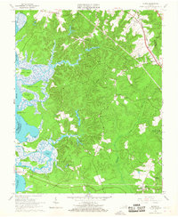
1965 Map of Norge
USGS Topo · Published 1967About this map
The Chickahominy River defines the western edge of this James City County landscape, where tidal flats and marshy islands like Yarmouth Island and Wright Island meet the upland forests. Inland, the mid-1960s terrain is characterized by a series of millponds and creeks, including Cranstons Pond, Jolly Pond, and Warburton Pond. The settlement pattern follows the Chesapeake and Ohio railroad corridor in the northeast, connecting Norge and Lightfoot, while scattered homesteads and landings such as Shipyard Landing and Claybank Landing hint at a long history of river-access commerce.
Find a feature on this map
46 named features on this map. Tap any name to fly to it.
Don’t see what you’re looking for? This feature index may not catch every label — zoom into the map to look around manually.
Map Details
Editions of this 1965 Norge Map
3 editions found
Other maps of this area

1906 · Williamsburg
USGS Topo · 1:62,500

1907 · Yorktown
USGS Topo · 1:62,500

1917 · Toano
USGS Topo · 1:62,500

1918 · Toano
USGS Topo · 1:62,500

1919 · Surry
USGS Topo · 1:62,500

1943 · Yorktown
USGS Topo · 1:62,500

1943 · Richmond
USGS Topo · 1:250,000

1949 · Richmond
USGS Topo · 1:250,000

1950 · Cobham Bay
USGS Topo · 1:24,000
1951 · Williamsburg
USGS Topo · 1:24,000