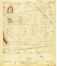
1918 Map of Noria
USGS Topo · Published 1931About this map
Kilbourne Hole, Hunts Hole, and Phillips Hole dominate this arid landscape near the border of New Mexico and Chihuahua. These significant depressions define the topography of the Potrillo volcanic field as it was surveyed just after the turn of the century. The Southern Pacific railroad cuts diagonally across the desert, serving as the primary infrastructure link for small rail stops and ranching outposts.
Find a feature on this map
14 named features on this map. Tap any name to fly to it.
Don’t see what you’re looking for? This feature index may not catch every label — zoom into the map to look around manually.
Map Details
Editions of this 1918 Noria Map
2 editions found
Other maps of this area

1891 · Las Cruces
USGS Topo · 1:125,000

1893 · Las Cruces
USGS Topo · 1:125,000

1917 · Canutillo
USGS Topo · 1:62,500

1917 · Noria
USGS Topo · 1:62,500

1917 · Mt. Riley
USGS Topo · 1:62,500

1918 · Mt. Riley
USGS Topo · 1:62,500

1918 · Noria
USGS Topo · 1:62,500

1919 · Canutillo
USGS Topo · 1:62,500

1929 · Mt. Riley
USGS Topo · 1:62,500

1941 · Aden
USGS Topo · 1:62,500