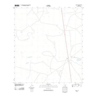
2010 Map of Norias
USGS Topo · Published 2010About this map
Norias serves as a central hub in this section of the South Texas brush country, where the landscape is defined by vast tracts of ranch land and numerous small, unnamed ephemeral water bodies. The settlement is positioned along the primary north-south corridor of Route 77, which remains the dominant transportation artery through this quiet cattle-ranching region. The presence of the Norias Cemetery east of the main road provides a significant point of interest for genealogists and local historians, anchoring the site of this historic ranching community. The map reveals the characteristic spatial patterns of Kenedy County, with sparse development and a focus on essential infrastructure such as windmills and livestock water sources that support large-scale ranching operations.
Find a feature on this map
3 named features on this map. Tap any name to fly to it.
Don’t see what you’re looking for? This feature index may not catch every label — zoom into the map to look around manually.
Map Details
Editions of this 2010 Norias Map
This is the sole edition of this map. No revisions or reprints were ever made.
Other maps of this area

1921 · Tarida Ranch
USGS Topo · 1:62,500

1922 · La Sal Vieja
USGS Topo · 1:62,500

1923 · Armstrong
USGS Topo · 1:62,500

1923 · Saltillo Ranch
USGS Topo · 1:62,500

1953 · Brownsville
USGS Topo · 1:250,000

1956 · Pita Camp
USGS Topo · 1:24,000
1956 · Armstrong
USGS Topo · 1:24,000
1956 · San Pedro Ranch
USGS Topo · 1:24,000

1956 · Julian
USGS Topo · 1:24,000

1956 · Saltillo Well
USGS Topo · 1:24,000