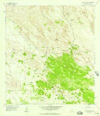
1956 Map of San Pedro Ranch
USGS Topo · Published 1957About this map
San Pedro Ranch anchors this portion of Kenedy County, where life and livestock depended entirely on a network of water infrastructure across an arid landscape. The terrain is dominated by vast fields of Shifting Sand Dunes, some reaching elevations of seventy-four feet, which dictates the layout of the cattle industry here. The map reveals the critical importance of groundwater, with dozens of named water sources scattered across the dunes, from the Potrero No 1 Artesian Well to the San Francisco Windmill.
Find a feature on this map
27 named features on this map. Tap any name to fly to it.
Don’t see what you’re looking for? This feature index may not catch every label — zoom into the map to look around manually.
Map Details
Editions of this 1956 San Pedro Ranch Map
3 editions found
Other maps of this area

1923 · Armstrong
USGS Topo · 1:62,500

1923 · Saltillo Ranch
USGS Topo · 1:62,500

1928 · Sarita
USGS Topo · 1:125,000

1950 · Corpus Christi
USGS Topo · 1:250,000

1952 · Sarita 4 SE
USGS Topo · 1:24,000

1953 · Brownsville
USGS Topo · 1:250,000

1954 · La Parra Ranch SW
USGS Topo · 1:24,000

1954 · Sarita
USGS Topo · 1:62,500
1955 · La Parra Ranch
USGS Topo · 1:62,500

1956 · Corpus Christi
USGS Topo · 1:250,000