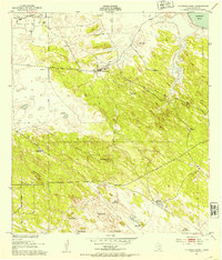
1954 Map of Sarita
USGS Topo · Published 1956About this map
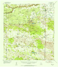
The town of Sarita stands as a lonely outpost along the Missouri Pacific railroad in this mid-century survey of Kenedy County. The landscape is defined by the legacy of the great South Texas ranching estates, with expansive holdings like La Paloma Ranch, Crocker Ranch, and the Santa Rosa Viejo Ranch anchoring the sparsely populated terrain. This is a region of moving earth and cattle, where Shifting Sand Dunes and the Medano de la Casa Blanca dominate the topography east of the tracks. The map records the working infrastructure of the era, from the Mifflin Trap and Mifflin Pens to the remote Turcotte stop. To the north, the winding course of the Cayo del Grullo meets the coastal plains, while scattered windmills and tanks like Cayo del Lake provide essential water in a landscape of brush and sand.
Find a feature on this map
24 named features on this map. Tap any name to fly to it.
Don’t see what you’re looking for? This feature index may not catch every label — zoom into the map to look around manually.
Map Details
Editions of this 1954 Sarita Map
This is the sole edition of this map. No revisions or reprints were ever made.
Other maps of this area

1921 · Falfurrias
USGS Topo · 1:125,000

1923 · Armstrong
USGS Topo · 1:62,500
1923 · Saltillo Ranch
USGS Topo · 1:62,500
1928 · Sarita
USGS Topo · 1:125,000

1949 · Mc Allen
USGS Topo · 1:250,000

1950 · Corpus Christi
USGS Topo · 1:250,000
1952 · Riviera Beach
USGS Topo · 1:24,000
1952 · La Parra Ranch
USGS Topo · 1:24,000
1952 · Riviera Beach
USGS Topo · 1:62,500

1953 · Brownsville
USGS Topo · 1:250,000