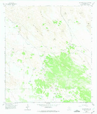
1956 Map of San Pedro Ranch
USGS Topo · Published 1975About this map
The San Pedro Ranch landscape in Kenedy County is defined by an intricate network of Shifting Sand Dunes, where elevations rise and fall across the brushland of the South Texas plains. Mapping work conducted by the Geological Survey reveals a remote ranching environment where survival depended entirely on scattered water sources. The map records a high density of named wells and windmills, such as the San Antonio Windmill and Santa Cruz Well, which anchored the local cattle operations. These features, connected by a web of unimproved dirt roads and property fences, illustrate the spatial organization of early-to-mid 20th-century ranching. The presence of San Pedro and family-named sites like La Piedra Well provides specific points of interest for genealogists and local historians tracing the heritage of this sparsely populated coastal prairie region.
Find a feature on this map
41 named features on this map. Tap any name to fly to it.
Don’t see what you’re looking for? This feature index may not catch every label — zoom into the map to look around manually.
Map Details
Editions of this 1956 San Pedro Ranch Map
3 editions found
Other maps of this area

1923 · Armstrong
USGS Topo · 1:62,500

1923 · Saltillo Ranch
USGS Topo · 1:62,500

1928 · Sarita
USGS Topo · 1:125,000

1950 · Corpus Christi
USGS Topo · 1:250,000

1952 · Sarita 4 SE
USGS Topo · 1:24,000

1953 · Brownsville
USGS Topo · 1:250,000

1954 · La Parra Ranch SW
USGS Topo · 1:24,000

1954 · Sarita
USGS Topo · 1:62,500
1955 · La Parra Ranch
USGS Topo · 1:62,500

1956 · Corpus Christi
USGS Topo · 1:250,000