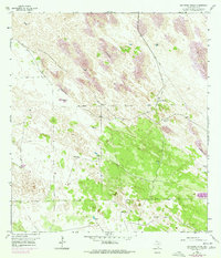
1956 Map of San Pedro Ranch
USGS Topo · Published 1977About this map
The San Pedro Ranch anchors this portion of Kenedy County, illustrating the vital infrastructure required for life and industry in the South Texas brush country during the mid-20th century. Water management is the defining characteristic of this landscape, as evidenced by a sophisticated network of wells and windmills. Named watering points like Potrero No 1 Well, Agua Dulce Well, and the Rodeo Windmill are scattered throughout, providing lifeblood to the cattle operations. The topography is dominated by extensive Shifting Sand Dunes, which are meticulously differentiated between active and stabilized formations. Long stretches of Fence lines cut across the terrain, marking property boundaries and grazing divisions. Localized sites such as Piedra Trap Windmill and San Antonio Windmill further highlight the specialized ranching structures that once served the large-scale holdings of the region.
Find a feature on this map
23 named features on this map. Tap any name to fly to it.
Don’t see what you’re looking for? This feature index may not catch every label — zoom into the map to look around manually.
Map Details
Editions of this 1956 San Pedro Ranch Map
3 editions found
Other maps of this area

1923 · Armstrong
USGS Topo · 1:62,500

1923 · Saltillo Ranch
USGS Topo · 1:62,500

1928 · Sarita
USGS Topo · 1:125,000

1950 · Corpus Christi
USGS Topo · 1:250,000

1952 · Sarita 4 SE
USGS Topo · 1:24,000

1953 · Brownsville
USGS Topo · 1:250,000

1954 · La Parra Ranch SW
USGS Topo · 1:24,000

1954 · Sarita
USGS Topo · 1:62,500
1955 · La Parra Ranch
USGS Topo · 1:62,500

1956 · Corpus Christi
USGS Topo · 1:250,000