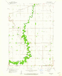
1959 Map of Norman
USGS Topo · Published 1960About this map
The Sheyenne River snakes in tight, dense oxbows through the heart of this Red River Valley landscape, defining the character of the borderlands between Cass and Richland Counties. In the late 1950s, this area remained primarily agricultural, anchored by the small settlement of Norman and a network of rural schoolhouses such as School No 19 and School No 5. The northern portion of the map is intersected by the Northern Pacific railroad, which cuts a straight line through the townships of Warren and Stanley. For those tracing family ties to the region, the map identifies local burial grounds including Norman Cem and Dokken Cem, providing essential geographic context for mid-century rural North Dakota life before the further consolidation of these small prairie communities.
Find a feature on this map
15 named features on this map. Tap any name to fly to it.
Don’t see what you’re looking for? This feature index may not catch every label — zoom into the map to look around manually.
Map Details
Editions of this 1959 Norman Map
2 editions found
Other maps of this area

1895 · Fargo
USGS Topo · 1:125,000

1895 · Casselton
USGS Topo · 1:125,000

1897 · Fargo
USGS Topo · 1:125,000

1897 · Casselton
USGS Topo · 1:125,000

1953 · Fargo
USGS Topo · 1:250,000

1956 · Fargo
USGS Topo · 1:250,000

1959 · Kindred
USGS Topo · 1:24,000

1959 · South West Fargo
USGS Topo · 1:24,000

1959 · Fargo South
USGS Topo · 1:24,000

1959 · Hickson
USGS Topo · 1:24,000