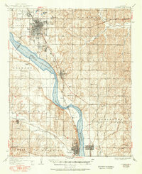
1936 Map of Norman
USGS Topo · Published 1951About this map
The University of Oklahoma anchors the northern portion of this landscape, with its North Campus and South Campus flanking the established streets of Norman. The Canadian River serves as a wide physical boundary between Cleveland and McClain counties, crossed only by the Norman Bridge. This mid-century survey illustrates a rural economy organized around small school districts and river transport, where the Santa Fe railroad line connects the primary hubs of Noble, Lexington, and Purcell. Away from the river, the terrain is dotted with local landmarks like Westheimer Field and the State Hospital. Genealogists will find significant value in the documentation of numerous country schools, such as Canada Sch and Goldsby Sch, alongside rural burial grounds including Dripping Springs Cem and Washington Cem.
Find a feature on this map
63 named features on this map. Tap any name to fly to it.
Don’t see what you’re looking for? This feature index may not catch every label — zoom into the map to look around manually.
Map Details
Editions of this 1936 Norman Map
5 editions found

Other maps of this area

1892 · Moore
USGS Topo · 1:62,500

1893 · Norman
USGS Topo · 1:62,500

1893 · Oklahoma City
USGS Topo · 1:62,500

1898 · Purcell
USGS Topo · 1:125,000

1898 · Pauls Valley
USGS Topo · 1:125,000

1902 · Pauls Valley
USGS Topo · 1:125,000

1902 · Rush Springs
USGS Topo · 1:125,000

1904 · Chickasha
USGS Topo · 1:125,000

1910 · McComb
USGS Topo · 1:62,500

1925 · Norman NO 2
USGS Topo · 1:24,000