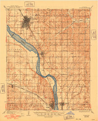
1936 Map of Norman
USGS Topo · Published 1948About this map
The Canadian River carves a winding path through the heart of the central Oklahoma plains, serving as the primary geographic dividing line between Cleveland and McClain Counties. Along its banks, the settlement of Norman is already established as a primary regional hub, featuring the extensive grounds of the State Hospital and a dense urban grid connected by the Oklahoma Electric railway. To the south, the Atchison Topeka and Santa Fe railroad corridor anchors smaller agricultural and transit points like Noble, Washington, and Purcell.
Find a feature on this map
61 named features on this map. Tap any name to fly to it.
Don’t see what you’re looking for? This feature index may not catch every label — zoom into the map to look around manually.
Map Details
Editions of this 1936 Norman Map
5 editions found

Other maps of this area

1892 · Moore
USGS Topo · 1:62,500

1893 · Norman
USGS Topo · 1:62,500

1893 · Oklahoma City
USGS Topo · 1:62,500

1898 · Purcell
USGS Topo · 1:125,000

1898 · Pauls Valley
USGS Topo · 1:125,000

1902 · Pauls Valley
USGS Topo · 1:125,000

1902 · Rush Springs
USGS Topo · 1:125,000

1904 · Chickasha
USGS Topo · 1:125,000

1910 · McComb
USGS Topo · 1:62,500

1925 · Norman NO 2
USGS Topo · 1:24,000