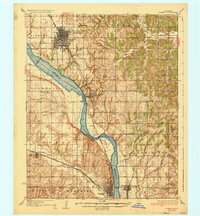
1936 Map of Norman
USGS Topo · Published 1936About this map
The University of Oklahoma and the State Hospital anchor the growing city of Norman during the mid-1930s, a period when the regional landscape was defined by the winding course of the Canadian River. This survey captures the transition between the urban grid of the city and the surrounding agricultural townships, including Liberty, Noble, and Lexington. A notable transportation network is visible, featuring the Atchison Topeka and Santa Fe and the Oklahoma Railway (Electric), which connected these communities before the dominance of modern highways. Rural life is documented through a dense distribution of country schools such as New Hope Sch and Capshaw Sch, alongside landmarks like Woody Chapel and the Fairview Cem. The map illustrates the geographical challenges of the era, showing the Norman Bridge and a Toll Bridge as critical crossings over the river's wide floodplains.
Find a feature on this map
61 named features on this map. Tap any name to fly to it.
Don’t see what you’re looking for? This feature index may not catch every label — zoom into the map to look around manually.
Map Details
Editions of this 1936 Norman Map
5 editions found

Other maps of this area

1892 · Moore
USGS Topo · 1:62,500

1893 · Norman
USGS Topo · 1:62,500

1893 · Oklahoma City
USGS Topo · 1:62,500

1898 · Purcell
USGS Topo · 1:125,000

1898 · Pauls Valley
USGS Topo · 1:125,000

1902 · Pauls Valley
USGS Topo · 1:125,000

1902 · Rush Springs
USGS Topo · 1:125,000

1904 · Chickasha
USGS Topo · 1:125,000

1910 · McComb
USGS Topo · 1:62,500

1925 · Norman NO 2
USGS Topo · 1:24,000