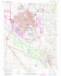
1965 Map of Norman
USGS Topo · Published 1983About this map
The University of Oklahoma dominates the central landscape of this mid-1960s survey, showing the campus layout and Owen Stadium just south of the historic Norman townsite. The era's institutional footprint is substantial, featuring the sprawling grounds of the Central State Hospital and several research facilities, including the Norman Research Park and Westheimer Field. To the south, the city's suburban expansion is checked by the wide, braided channel of the Canadian River, which forms the county line between Cleveland and McClain.
Find a feature on this map
54 named features on this map. Tap any name to fly to it.
Don’t see what you’re looking for? This feature index may not catch every label — zoom into the map to look around manually.
Map Details
Editions of this 1965 Norman Map
3 editions found
Other maps of this area

1892 · Moore
USGS Topo · 1:62,500

1893 · Norman
USGS Topo · 1:62,500

1893 · Oklahoma City
USGS Topo · 1:62,500

1898 · Purcell
USGS Topo · 1:125,000

1904 · Chickasha
USGS Topo · 1:125,000

1925 · Norman NO 2
USGS Topo · 1:24,000

1934 · Moore
USGS Topo · 1:62,500

1936 · Norman
USGS Topo · 1:62,500

1938 · Moore
USGS Topo · 1:62,500

1954 · Oklahoma City
USGS Topo · 1:250,000