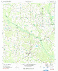
1973 Map of Norman Park
USGS Topo · Published 1991About this map
Norman Park sits at the heart of this South Georgia landscape, where the confluence of agricultural life and early transportation networks is clearly visible. The town center is anchored by Baker Mem Park and the nearby St Lukes Ch, while an Old Railroad Grade and a dedicated Landing Strip indicate the area's evolving transit corridors. To the northeast, the smaller settlement of Crosland marks the junction of local routes near the boundary of Colquitt, Worth, and Tift counties.
Find a feature on this map
29 named features on this map. Tap any name to fly to it.
Don’t see what you’re looking for? This feature index may not catch every label — zoom into the map to look around manually.
Map Details
Editions of this 1973 Norman Park Map
2 editions found
Other maps of this area

1953 · Waycross
USGS Topo · 1:250,000

1956 · Doerun
USGS Topo · 1:62,500

1958 · Waycross
USGS Topo · 1:250,000

1973 · Ty Ty
USGS Topo · 1:24,000

1973 · Norman Park
USGS Topo · 1:24,000

1973 · Tifton West
USGS Topo · 1:24,000

1973 · Omega
USGS Topo · 1:24,000
1974 · Tempy
USGS Topo · 1:24,000
1974 · Sigsbee
USGS Topo · 1:24,000

1974 · Pineboro
USGS Topo · 1:24,000