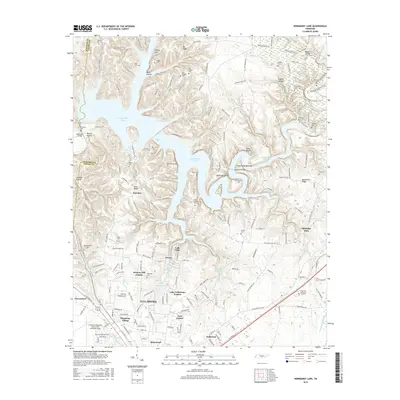
2016 Map of Normandy Lake
USGS Topo · Published 2016About this map
Normandy Lake dominates the landscape of this region, its fingers reaching into hollows and along the Duck River valley northwest of Tullahoma. The transition from the established city center to the surrounding hills is marked by numerous residential developments including Hickory Hill Estates and Lake Tullahoma Estates. To the north, the geography is defined by a series of family-named landmarks and cemeteries, such as Hickerson Cem and Tomes Cem, reflecting the area's deep-rooted genealogy. Significant natural features like Rutledge Falls and Machine Falls near the Short Spring state natural area illustrate the dramatic topography of the Highland Rim. Transportation and infrastructure are anchored by the Tullahoma Regional Airport/Wm Northern Field and several crossings over the lake, including Anthony Bridge and Huffman Bridge, which connect rural communities like Fairview to the city.
Find a feature on this map
211 named features on this map. Tap any name to fly to it.
Don’t see what you’re looking for? This feature index may not catch every label — zoom into the map to look around manually.
Map Details
Editions of this 2016 Normandy Lake Map
This is the sole edition of this map. No revisions or reprints were ever made.
Other maps of this area

1913 · Hollow Springs
USGS Topo · 1:62,500

1936 · Ovoca
USGS Topo · 1:24,000

1936 · Fredonia
USGS Topo · 1:24,000

1936 · Manchester
USGS Topo · 1:24,000

1936 · Cumberland Springs
USGS Topo · 1:24,000

1936 · Noah
USGS Topo · 1:24,000

1936 · Wartrace
USGS Topo · 1:24,000

1936 · Camp Peay
USGS Topo · 1:24,000

1936 · Capitol Hill
USGS Topo · 1:24,000

1936 · Normandy
USGS Topo · 1:24,000