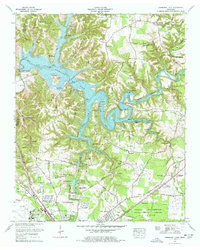
1976 Map of Normandy Lake
USGS Topo · Published 1977About this map
The Normandy Dam anchors the landscape of this 1970s survey, holding back the waters of the Duck River to form the sprawling Normandy Lake. This man-made reservoir winds through the hills of Coffee and Bedford Counties, submerged valleys that once held agricultural lands now serving as recreation sites like the Barton Spring Public Use Area. To the south, the city of Tullahoma shows significant expansion with residential developments such as Hickerson Hill Estates and Homaway Village clustered near the Arnold Engineering Development Center.
Find a feature on this map
89 named features on this map. Tap any name to fly to it.
Don’t see what you’re looking for? This feature index may not catch every label — zoom into the map to look around manually.
Map Details
Editions of this 1976 Normandy Lake Map
4 editions found
Other maps of this area

1913 · Hollow Springs
USGS Topo · 1:62,500

1936 · Ovoca
USGS Topo · 1:24,000

1936 · Fredonia
USGS Topo · 1:24,000

1936 · Manchester
USGS Topo · 1:24,000

1936 · Cumberland Springs
USGS Topo · 1:24,000

1936 · Noah
USGS Topo · 1:24,000

1936 · Wartrace
USGS Topo · 1:24,000

1936 · Camp Peay
USGS Topo · 1:24,000

1936 · Capitol Hill
USGS Topo · 1:24,000

1936 · Normandy
USGS Topo · 1:24,000