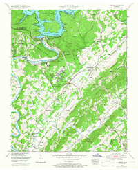
1952 Map of Norris
USGS Topo · Published 1966About this map
Norris Dam anchors this landscape, holding back the waters of the Clinch River and creating the irregular shoreline of Lake. Developed following the creation of the Tennessee Valley Authority, the planned community of Norris and the Norris Freeway represent a mid-century shift in local infrastructure and settlement patterns. Beyond the modern engineering, the map preserves the older rural character of the area, defined by ridges like Big Ridge and Lone Mountain. These uplands are home to numerous historic congregations and family burial grounds, including Island Home Church, Sinking Springs Church, and the Dew Cemetery. The presence of several local institutions, such as Riverview School and Glen Alpine School, alongside the Norris Reservation Boundary, illustrates the transition from traditional Appalachian farmsteads to a managed regional water and power system.
Find a feature on this map
86 named features on this map. Tap any name to fly to it.
Don’t see what you’re looking for? This feature index may not catch every label — zoom into the map to look around manually.
Map Details
Editions of this 1952 Norris Map
3 editions found
Other maps of this area

1893 · Briceville
USGS Topo · 1:125,000

1895 · Briceville
USGS Topo · 1:125,000

1896 · Briceville
USGS Topo · 1:125,000

1897 · Maynardville
USGS Topo · 1:125,000

1900 · Maynardville
USGS Topo · 1:125,000

1935 · Fountain City
USGS Topo · 1:24,000

1936 · Gorryton
USGS Topo · 1:48,000

1936 · Jacksboro
USGS Topo · 1:24,000

1936 · White Hollow
USGS Topo · 1:24,000

1936 · La Follette
USGS Topo · 1:48,000