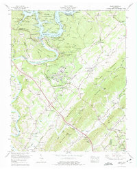
1973 Map of Norris
USGS Topo · Published 1975About this map
Norris Dam anchors this landscape, holding back the waters of Norris Lake where the Clinch River meets Cove Creek. This 1973 revision captures the area's development into a regional recreational and cultural hub, featuring the Museum of Appalachia and the expansive Norris Municipal Park. The terrain is defined by a series of parallel ridges, including Bluebird Ridge and Lone Mountain Ridge, which hem in long-established communities like Andersonville and Bethel.
Find a feature on this map
71 named features on this map. Tap any name to fly to it.
Don’t see what you’re looking for? This feature index may not catch every label — zoom into the map to look around manually.
Map Details
Editions of this 1973 Norris Map
2 editions found
Other maps of this area

1893 · Briceville
USGS Topo · 1:125,000

1895 · Briceville
USGS Topo · 1:125,000

1896 · Briceville
USGS Topo · 1:125,000

1897 · Maynardville
USGS Topo · 1:125,000

1900 · Maynardville
USGS Topo · 1:125,000

1935 · Fountain City
USGS Topo · 1:24,000

1936 · Gorryton
USGS Topo · 1:48,000

1936 · Jacksboro
USGS Topo · 1:24,000

1936 · White Hollow
USGS Topo · 1:24,000

1936 · La Follette
USGS Topo · 1:48,000