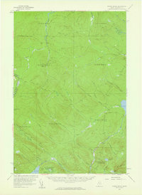
1957 Map of Norris Brook
USGS Topo · Published 1960About this map
St John River and the Penobscot River headwaters dominate this 1957 topographic study of Somerset County, Maine. The map details a landscape defined by an intricate network of waterways including the Southwest Branch St John River and the North Branch Penobscot River. This area, situated along the International Boundary between Maine and Quebec, was primarily managed as timberland, as evidenced by the vast network of unnamed jeep trails and the lack of permanent civilian settlements. Distinctive features like the Big Bog and Little St John Lake emphasize the poorly drained, glacial character of the terrain. The presence of a Gravel Pit near Big Bog suggests local road maintenance or logging infrastructure in an era when this region was remote and accessible only by unpaved tracks.
Find a feature on this map
45 named features on this map. Tap any name to fly to it.
Don’t see what you’re looking for? This feature index may not catch every label — zoom into the map to look around manually.
Map Details
Editions of this 1957 Norris Brook Map
3 editions found

Other maps of this area

1927 · Sandy Bay
USGS Topo · 1:48,000

1930 · Sandy Bay
USGS Topo · 1:62,500

1944 · Sandy Bay
USGS Topo · 1:62,500

1949 · Jackman
USGS Topo · 1:250,000

1954 · Seboomook Lake
USGS Topo · 1:62,500

1954 · Baker Lake
USGS Topo · 1:62,500

1954 · St. John Pond
USGS Topo · 1:62,500

1954 · Presque Isle
USGS Topo · 1:250,000

1954 · Millinocket
USGS Topo · 1:250,000

1956 · Penobscot Lake
USGS Topo · 1:62,500