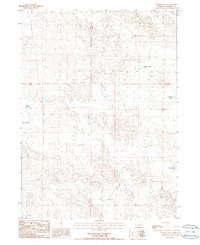
1986 Map of Norris Lake
USGS Topo · Published 1986About this map
The vast Nebraska Sandhills of Morrill County define this landscape, a region where shallow groundwater and depressions create a network of isolated basins and alkaline lakes. In the mid-1980s, these waterscapes, including Norris Lake and Kleman Lake, served as vital points of reference in an otherwise undulating terrain of sand dunes and meadows. The map reveals the intricate natural drainage and ponding characteristic of the area, with Mud Lakes and Box Lake scattered across the northern and western sections. Transportation is limited to a sparse network of improved and unimproved roads that navigate between these water bodies. This survey provides a clear view of the area's hydrology before modern climatic shifts, documenting the precise footprints of Peer Lake and Roach Lake as they existed during the field inspections of 1984.
Find a feature on this map
7 named features on this map. Tap any name to fly to it.
Don’t see what you’re looking for? This feature index may not catch every label — zoom into the map to look around manually.
Map Details
Editions of this 1986 Norris Lake Map
This is the sole edition of this map. No revisions or reprints were ever made.
Other maps of this area

1896 · Browns Creek
USGS Topo · 1:125,000

1899 · Browns Creek
USGS Topo · 1:125,000

1949 · Lynn
USGS Topo · 1:62,500

1950 · Storm Lake
USGS Topo · 1:62,500

1954 · Scottsbluff
USGS Topo · 1:250,000

1958 · Scottsbluff
USGS Topo · 1:250,000

1965 · Broadwater NW
USGS Topo · 1:24,000

1965 · Broadwater NE
USGS Topo · 1:24,000
1971 · Tar Valley
USGS Topo · 1:24,000

1985 · Crescent Lake
USGS Topo · 1:100,000