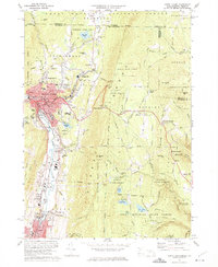
1973 Map of North Adams
USGS Topo · Published 1975About this map
Industrial and educational centers anchor this landscape, where the North Adams city center is packed with civic landmarks like City Hall, the Library, and an Armory. The presence of State College, St Josephs High Sch, and several local schools illustrates a well-developed mid-century community. The terrain is defined by the steep elevation changes of the surrounding state forests, with the Hoosac Tunnel cutting through the mountain to the east, a marvel of engineering that allowed the Penn Central railroad to bypass the formidable ridge.
Find a feature on this map
93 named features on this map. Tap any name to fly to it.
Don’t see what you’re looking for? This feature index may not catch every label — zoom into the map to look around manually.
Map Details
Editions of this 1973 North Adams Map
4 editions found
Other maps of this area

1886 · Greylock
USGS Topo · 1:62,500

1886 · Hawley
USGS Topo · 1:62,500

1889 · Wilmington
USGS Topo · 1:62,500

1890 · Hawley
USGS Topo · 1:62,500

1891 · Wilmington
USGS Topo · 1:62,500

1891 · Greylock
USGS Topo · 1:62,500

1893 · Greylock
USGS Topo · 1:62,500

1894 · Hawley
USGS Topo · 1:62,500

1898 · Bennington
USGS Topo · 1:62,500

1898 · Greylock
USGS Topo · 1:62,500