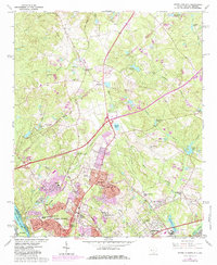
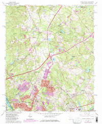
1964 Map of North Augusta
USGS Topo · Published 1984About this map
North Augusta and the adjacent community of Belvedere anchor this study of the borderlands between South Carolina and Georgia as they appeared in the 1960s, with later updates. The landscape is defined by the proximity of the Savannah River and a series of industrial and residential developments that follow the Seaboard Coast Line and various old railroad grades. Significant local landmarks like Pineview Memorial Gardens and the North Augusta Golf Club point to the area's mid-century expansion, while numerous claypits suggest a history of resource extraction tied to the local geology.
Find a feature on this map
54 named features on this map. Tap any name to fly to it.
Don’t see what you’re looking for? This feature index may not catch every label — zoom into the map to look around manually.
Map Details
Editions of this 1964 North Augusta Map
5 editions found
Other maps of this area

1892 · Mc Cormick
USGS Topo · 1:125,000

1912 · Mc Cormick
USGS Topo · 1:125,000

1920 · Clarks Hill
USGS Topo · 1:48,000

1921 · Augusta
USGS Topo · 1:62,500

1921 · Clarks Hill
USGS Topo · 1:62,500

1922 · Hephzibah
USGS Topo · 1:62,500

1923 · Warrenville
USGS Topo · 1:48,000

1928 · Warrenville
USGS Topo · 1:62,500

1941 · Clarks Hill
USGS Topo · 1:62,500

1942 · Clarks Hill
USGS Topo · 1:62,500