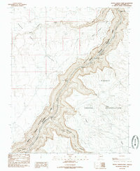
1985 Map of North Canyon Point
USGS Topo · Published 1985About this map
Colorado River whitewater and steep canyon geography dominate this 1985 survey of Coconino County. The map details a significant stretch of Marble Canyon, documenting a sequence of technical water features including Twentyfive Mile Rapids and Twentynine Mile Rapids. The eastern bank is defined by the Navajo Indian Reservation boundary, while the western side falls within Grand Canyon National Park.
Find a feature on this map
22 named features on this map. Tap any name to fly to it.
Don’t see what you’re looking for? This feature index may not catch every label — zoom into the map to look around manually.
Map Details
Editions of this 1985 North Canyon Point Map
This is the sole edition of this map. No revisions or reprints were ever made.
Other maps of this area

1886 · Echo Cliffs
USGS Topo · 1:250,000

1891 · Echo Cliffs
USGS Topo · 1:250,000

1954 · Emmett Wash NE
USGS Topo · 1:24,000

1954 · Emmett Wash NW
USGS Topo · 1:24,000

1954 · Nankoweap
USGS Topo · 1:62,500

1954 · Tanner Wash
USGS Topo · 1:62,500

1954 · Emmett Wash
USGS Topo · 1:62,500

1954 · Shinumo Altar
USGS Topo · 1:62,500

1956 · Marble Canyon
USGS Topo · 1:250,000

1959 · Marble Canyon
USGS Topo · 1:250,000