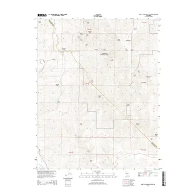
2015 Map of North Chalone Peak
USGS Topo · Published 2015About this map
Pinnacles National Park dominates this central California landscape, where the jagged volcanic remains of the Neenach Volcano have been shifted by the San Andreas Fault. High elevation points like North Chalone Peak and South Chalone Peak provide a dramatic contrast to the low-lying Salinas River visible at the southwestern edge of the survey. The topography is defined by sharp vertical features such as Machete Ridge, The Fingers, and the Resurrection Wall, alongside deep drainages like Stonewall Canyon and Bear Gulch. Human infrastructure is largely confined to the western perimeter, where residential labels like Silvear Dr and Detweiler Ln meet the wilderness. For genealogists and local historians, named locations like Star Flat and Murphy Flat at the eastern boundary provide specific points of interest within the broader network of springs and canyons, including Parson Spring and George Hansen Canyon.
Find a feature on this map
54 named features on this map. Tap any name to fly to it.
Don’t see what you’re looking for? This feature index may not catch every label — zoom into the map to look around manually.
Map Details
Editions of this 2015 North Chalone Peak Map
This is the sole edition of this map. No revisions or reprints were ever made.
Other maps of this area

1912 · Metz
USGS Topo · 1:31,680

1915 · Soledad
USGS Topo · 1:62,500

1919 · San Benito
USGS Topo · 1:62,500

1921 · Gonzales
USGS Topo · 1:62,500

1921 · Metz
USGS Topo · 1:62,500

1931 · San Benito
USGS Topo · 1:62,500

1940 · Metz
USGS Topo · 1:62,500

1940 · Soledad
USGS Topo · 1:62,500

1940 · San Benito
USGS Topo · 1:62,500
1940 · Gonzales
USGS Topo · 1:62,500