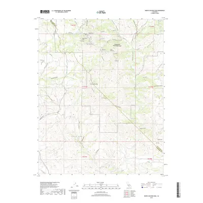
2018 Map of North Chalone Peak
USGS Topo · Published 2018About this map
Pinnacles National Park dominates the northern half of this landscape, showcasing a complex network of geological formations and hiking routes. Features such as Resurrection Wall, The Fingers, and Pinnacle Rocks highlight the dramatic terrain of the high peaks area. Further south, the elevations culminate at North Chalone Peak and South Chalone Peak, providing a clear view of the drainage patterns through Cherry Canyon and Wildhorse Canyon. The boundary between San Benito Co and Monterey Co cuts through these formations, where springs like Oak Tree Spring and Moses Spring provide critical water sources in an otherwise arid environment. The map details an extensive trail system, including the High Pks Tr and Balconies Cliffs Tr, which facilitate navigation through the steep gulches and ridges that define this portion of the Gabilan Range.
Find a feature on this map
101 named features on this map. Tap any name to fly to it.
Don’t see what you’re looking for? This feature index may not catch every label — zoom into the map to look around manually.
Map Details
Editions of this 2018 North Chalone Peak Map
This is the sole edition of this map. No revisions or reprints were ever made.
Other maps of this area

1912 · Metz
USGS Topo · 1:31,680

1915 · Soledad
USGS Topo · 1:62,500

1919 · San Benito
USGS Topo · 1:62,500

1921 · Gonzales
USGS Topo · 1:62,500

1921 · Metz
USGS Topo · 1:62,500

1931 · San Benito
USGS Topo · 1:62,500

1940 · Metz
USGS Topo · 1:62,500

1940 · Soledad
USGS Topo · 1:62,500

1940 · San Benito
USGS Topo · 1:62,500
1940 · Gonzales
USGS Topo · 1:62,500