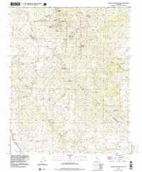
1995 Map of North Chalone Peak
USGS Topo · Published 1999About this map
Pinnacles National Monument dominates this mid-1990s survey, capturing the dramatic spires and ridges of the Gabilan Range on the border of Monterey and San Benito counties. The landscape is defined by the elevation gain between Chalone Creek and the high points of North Chalone Peak and South Chalone Peak. Human activity is concentrated around recreational and utility sites like the Chaparral Campground, Pinnacles Air Park, and the Bear Creek Picnic Area.
Find a feature on this map
38 named features on this map. Tap any name to fly to it.
Don’t see what you’re looking for? This feature index may not catch every label — zoom into the map to look around manually.
Map Details
Editions of this 1995 North Chalone Peak Map
This is the sole edition of this map. No revisions or reprints were ever made.
Other maps of this area

1912 · Metz
USGS Topo · 1:31,680

1915 · Soledad
USGS Topo · 1:62,500

1919 · San Benito
USGS Topo · 1:62,500

1921 · Gonzales
USGS Topo · 1:62,500

1921 · Metz
USGS Topo · 1:62,500

1931 · San Benito
USGS Topo · 1:62,500

1940 · Metz
USGS Topo · 1:62,500

1940 · Soledad
USGS Topo · 1:62,500

1940 · San Benito
USGS Topo · 1:62,500
1940 · Gonzales
USGS Topo · 1:62,500