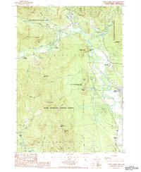
1987 Map of North Conway West
USGS Topo · Published 1987About this map
White Mountain National Forest dominates the interior of this 1980s landscape, where the confluence of the Ellis River and the Saco River defines the valley's settlement patterns. The map detail highlights the development of the corridor through Glen, Lower Bartlett, and Intervale, following the natural passage between the high ridges of Mt Pickering and the Moat Mountain range. For researchers, the map identifies specific river crossings such as Cooks Crossing and Rogers Crossing, alongside local landmarks like Cathedral Ledge and White Horse Ledge. The transition from the dense forests of Merriman State Forest to the village center of North Conway shows a region shaped by both its mountain geography and its established road and rail routes. Cultural markers, including a Cem near the Saco, provide essential reference points for tracing local family history and land use in Bartlett and Hales Location.
Find a feature on this map
44 named features on this map. Tap any name to fly to it.
Don’t see what you’re looking for? This feature index may not catch every label — zoom into the map to look around manually.
Map Details
Editions of this 1987 North Conway West Map
2 editions found
Other maps of this area

1894 · North Conway
USGS Topo · 1:62,500

1895 · Crawford Notch
USGS Topo · 1:62,500

1896 · Crawford Notch
USGS Topo · 1:62,500

1896 · North Conway
USGS Topo · 1:62,500

1930 · Ossipee Lake
USGS Topo · 1:62,500

1931 · Mt. Chocorua
USGS Topo · 1:62,500

1942 · North Conway
USGS Topo · 1:62,500

1945 · North Conway
USGS Topo · 1:62,500

1946 · Crawford Notch
USGS Topo · 1:62,500

1949 · Portland
USGS Topo · 1:250,000